 Project: 727 UNESCO IGCP “Geological heritage – sustainable management of geological hazards and water resources in transboundary region of Kyrgyzstan”
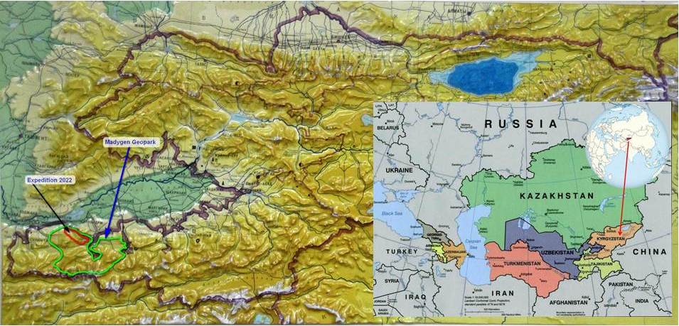
International geological expedition to “Madygen” Geopark . Exploration of the stratigraphic section “Gas” – Geological heritage of International importance.
The expedition under the auspices of UNESCO
Global Boundary Stratotype Sections and Points (GSSPs) between Bashkirian stage and Lower Moscovian substage in Turkestan – Alai (South Tian-Shan)
We invite researchers to take part in a paleontological and stratigraphic expedition to the South Tian-Shan in August 2022.
Expedition dates: August 12 – September 01, 2022
Kyrgyzstan is actively involved in the development of Geoparks. The country occupies almost the entire western part of the Tian-Shan, with enormous potential for the development of geoparks and geological tourism.
The Tian-Shan has a long geological history, from the Proterozoic to modern Quaternary rock deposits. A variety of geological structures, geological sections, landforms, and many aesthetic objects of the geological heritage create all the criteria for certain territories of the Tian-Shan to become geoparks.
Geopark Madygen is an excellent opportunity for international cooperation between specialists in stratigraphy, paleontology, and geology in general.
Upper Paleozoic deposits occupy a special place in the geological sections of the Southern Tian-Shan. According to geologists who have devoted themselves to the study of Central Asia, these sections can claim to be global reference stratotypes. At the same time, the border between the Bashkir and Moscow geological layers of the Carboniferous period in the southwestern Tian-Shan may become a place for a new “Golden spike”.
The main merit and research results belong to a group of scientists led by Dr. A.V. DZHENCHURAEVA, from the National Academy of Sciences of Kyrgyzstan.
In this regard, we are organizing a joint international expedition to obtain more modern information about the stratigraphic section “Gas” – an object of International importance. Based on the research results, we want to receive reliable estimates of international experts and receive an extended opinion of the international commission on stratigraphy.
Rationale:
The main results of studies of foraminifera and stratigraphy of Middle Carboniferous formations in the foothills of the Turkestan-Alai ridge of the South Tian-Shan are as follows:
- A detailed biostratigraphy scheme of the Bashkir and lower half of the Moscow stages was created. According to this scheme, the Bashkirian Stage is subdivided into seven Foraminiferal zones: the Plectostaffella bogdanovkensis Zone, the Plectostaffella seslavica – Semistaffella inconstans Zone, the Pseudostaffella Antiqua Zone, the Pseudostaffella praegorskyi Zone, the Profusulinella Primitivi rgoni rgonovichi zone, Profusulinella tidalwormrgoni rgoni rgonovichi zone. The Moscow Stage, the lower substage is subdivided into three zones: the Aljutovella aljutovica – Eofusulina triangula Zone, the Priscoidella priscoidea Zone, and the Pulchrella subpulchra – Moellerites bedakensis Zone.
- Identified species-indexes (markers) for drawing the interlayer boundary between the deposits of the Bashkir and Moscow stages in the South Tian-Shan. The highlighted markers will help to establish the “golden nails” in the geochronological timeline.
Justification of the border between the Bashkir and Moscow stages in the Southern Tian-Shan
Work on identification of species-markers of this boundary in stratotype layers, as well as in regions where in the deposits of the Bashkir and Moscow stages, work is being carried out to identify species-markers of this boundary in stratotype layers.
In this regard, an analysis of the border Bashkir-Moscow foraminiferal assemblages in the Southern Tian-Shan was carried out. As a result of the analysis, it was found that the most important for substantiating this boundary are representatives of the evolutionary lines Tikhonovichiella tikhonovichi – Aljutovella aljutovica, Verella spicata – Eofusulina triangula, Depratina praeprisca – D. prisca. This border is characterized by the excellent appearance in the upper zone of the Bashkirian stage of the species Verella spicata, Tikhonovichiella tikhonovichi, and Depratina praeprisca, and at the beginning of the Moscow Age, the appearance of: Eofusulina triangula, Aljutovella aljutovica, and Depratina prisca. This situation is recorded in all five sections studied. In some other regions of the world – Turkey, Spain, Donbass, the level of the Bashkir – Moscow stages are similar to the geological section in the Southern Tian-Shan.
However, in the presented evolutionary lines, there are representatives of the evolutionary lines Tikhonovichiella tikhonovichi – Aljutovella aljutovica and Depratina praeprisca – Depratina prisca, but there are no representatives of the line Verella spicata – Eofusulina triangula. A similar tracking position is also observed in the Southern Urals, where the beginning of the Moscow Stage is established by the appearance of the species Aljutovella aljutovica and Depratina prisca, where the lines Verella spicata – Eofusulina triangula are also absent.
Considering that the stratotype of the Bashkirian stage is located in the Urals, the stratotype of the Moscow stage is located in the Moscow region and there are no verellas or eofusulin there, the evolutionary line cannot have a correlation potential comparable to the species Aljutovella aljutovica and Depratina prisca. So, one of these two species Aljutovella aljutovica or Depratina prisca can be used as a marker of the lower boundary of the Moscow Stage. For the Tian-Shan marker species, the correlation role will be played by representatives of the evolutionary line Verella spicata – Eofusulina triangula.
As a result of studying the Bashkir-Moscow formations in the Turkestan-Alai ridge (South Tian-Shan), the following was established:
- Carbonate sedimentation continued throughout the Bashkir-Moscow time;
- A detailed study of the distribution of foraminifera in 5 studied sections made it possible to establish 7 foraminiferal zones in the Bashkirian Stage: Plectostaffella bogdanovkensis, Plectostaffella seslavica – Semistaffella inconstans, Pseudostaffella antiqua, Pseudostaffella antiqua, Pseudostaffella praegorskyi, Pseudostaffella. Aljutovella aljutovica, Aljutovella priscoidea, Fusulinella subpulchra.
- Analysis of foraminiferal zones of the boundary Bashkir-Moscow interval made it possible to establish three evolutionary lines of species development: Verella spicata –Eofusulina triangula, Depratina praeprisca –D. Prisca and Tikhonovichiella Tikhonovich, all of whose representatives were investigated in the Southern Tian-Shan. However, for the two international marker species we recommend only the last lines, Depratina praeprisca –D. priska and tikhonovichiella tikhonovichi.
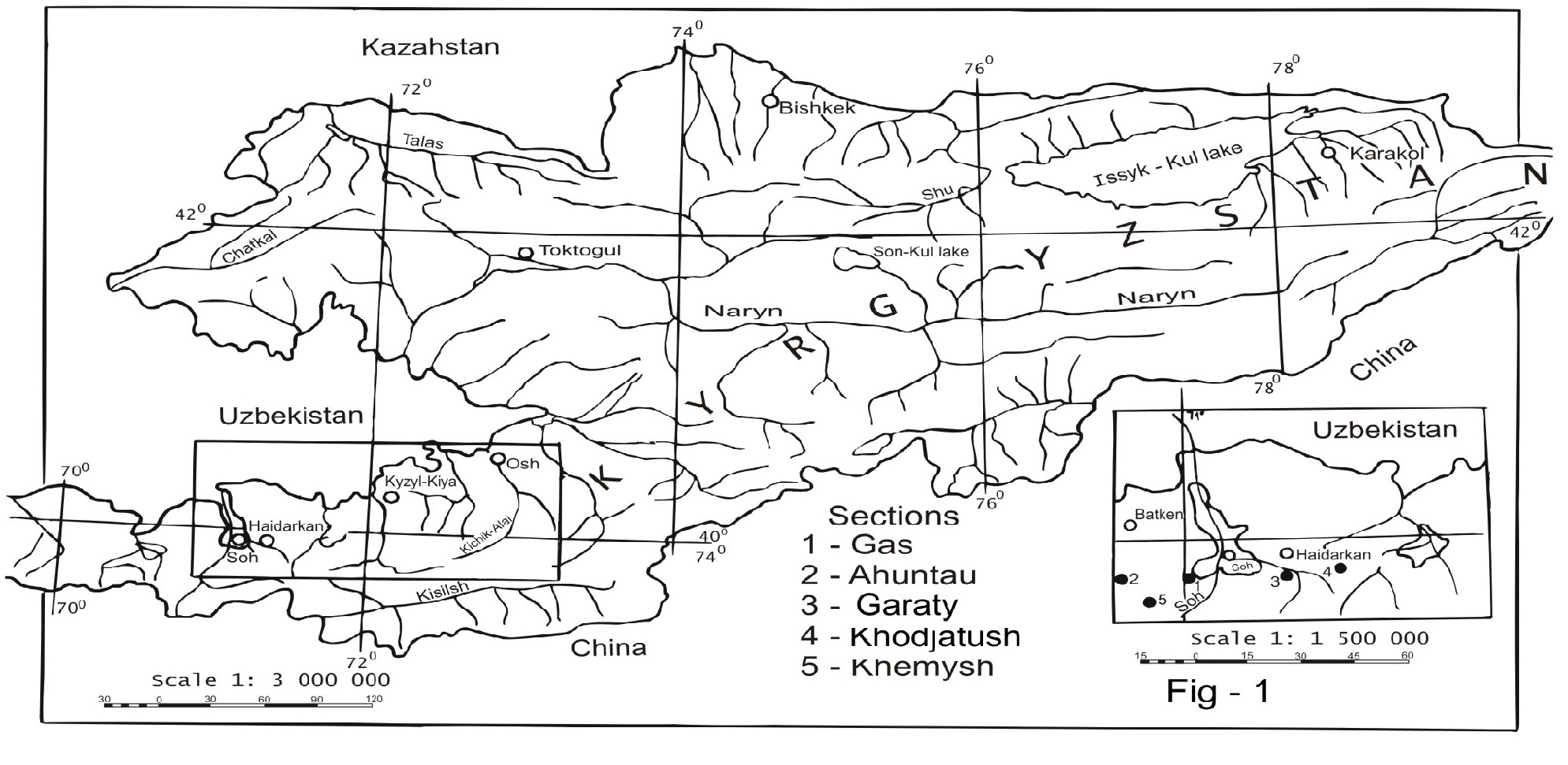
The last biostratigraphic scheme for the Carboniferous of Kyrgyzstan was compiled in 1990 during the implementation of the project “Compilation of regional stratigraphic schemes of the Precambrian and Paleozoic of Kyrgyzstan. The biostratigraphic scheme was drawn up according to the definitions of fossil fossils of orthostratigraphic groups – foraminifera, conodonts and brachiopods. These fossil remains were found in stable sections “Gaz”, “Akhuntau”, “Kshemysh”, “Khodjatush”, “Garaty”, in the Alai and Turkestan ridges of the South Tian-Shan. Based on the study of foraminifera and conodonts in these sections, the scheme of subdivision of the Lower – Middle Carboniferous was corrected. The Upper Carboniferous was studied using foraminifers from the reference sections of the Karachatyr Ridge in the Southern Tian-Shan.
The proposed biostratigraphic scheme was correlated with similar schemes in other regions of Central Asia. This scheme was supposed to be approved at a meeting of the Regional Interdepartmental Stratigraphic Committee (RISC), but due to the collapse of the Soviet Union, this committee ceased to exist. Therefore, in our further work, we used this biostratigraphic scheme in an unapproved version.
However, further work on the study of the Carboniferous of the Middle Tian-Shan (reference sections “Akbeit”, “Kodzhagul”, “Ichke”) made it possible to obtain new materials that made adjustments to the existing biostratigraphic scheme.
In the northeastern part of the Northern Tian-Shan, reference carbonate sections (“Boordu”, “Tekes”, “Tyup”) were also studied, which made it possible to supplement the characteristics of the Middle Carboniferous of the biostratigraphic scheme.
The study of the tier boundaries in the Carboniferous of the world, which began in recent years, with the aim of staking them out with “golden nails”, made it possible to attract this huge amount of material for solving this issue.
All this led to our research on the paleontological substantiation of the biostratigraphic scheme of the Carboniferous of Kyrgyzstan.
Thus, we argue that the reference stratigraphic boundary between the Bashkir and Moscow stages and the Global Boundary Stratotype Sections and Points (GSSPs) is located in the southern Tian-Shan of Kyrgyzstan.
Expedition objectives:
- – Research and obtaining materials about the geological heritage to justify the nomination dossier for the inclusion of the geological section “Gas” in the list of world natural heritage.
- – Confirm the belonging of geological sections to the International stratigraphic standard-standard for the lower boundary of the Moscow Stage of the Upper Devonian or a Global Boundary Stratotype Sections and Points (GSSPs) .
- – Reconstruction of geological history,
- – Use modern methods for a detailed study of the stratigraphic boundary between the Bashkir and Moscow stages of the Carboniferous period,
- – Research of markers,
- – Justification of the world-standard stratigraphic boundary between the Bashkir and Moscow stages,
- – Obtaining reliable data for the nomination of a stratigraphic section as a stratotype (reference),
- – An important goal of the expedition is to confirm the uniqueness of the geological section as the custodian of the international stratigraphic standard-standard in the South Tian-Shan,
- – Receive recognition of the International Stratigraphic Committee and the world geological community.
Expedition program:
We invite scientists and researchers to take part in a stratigraphic expedition. An international expedition is scheduled for August 2022. Further research will continue for several years to obtain representative materials to substantiate the stratigraphic boundary.
The results of other studies will be very useful and necessary for the creation of a geological museum on the territory of the Geopark.
We plan to receive materials for joint publications in world scientific journals.
We will welcome all interested paleontologists, biologists, geologists and others.
Program
Expedition duration 20 days
- Days 1 – 2. Meeting at the Osh airport. Accommodation in a guest house. Briefing, acquaintance
- Day 3. – Drive Osh – Gaz village – field camp,
- Days 4. – 18. Field research in the vicinity of the geological section,
- Day 19. – Return to Osh,
- Day 20. Transfer Osh – Airport. Homecoming
Organization of the expedition:
Currently, the Geological Society is encouraging sponsors to cooperate. Business and international organizations can participate in funding scientific and applied research in the future UNESCO Geopark.
We would be delighted to welcome research centers, associations or individual researchers willing to take part in scientific research.
Financial contributions for participation in the expedition will be used for renting transport, purchasing food, paying for the cook and technical staff, consumables, living in guest houses, etc.
The Tian-Shan Geological Society together with GeoExplorersClub Company will create the necessary conditions for comfortable field work.
- – We will provide the field camp with the necessary equipment: tents, kitchen, laboratory tents, shower, toilet, electric generator, etc.
- – We will provide visa support,
- – We will obtain all official permits for legal research and sampling of minerals,
- – We will provide the necessary logistics, meeting at the airport, accommodation in a guest house, etc.
We will create a good and friendly environment for joint research.
Project partners:
- – Kyrgyz State University of Geology, Mining and Development of Natural Resources,
- – GeoExplorersClub Company
Those wishing to participate in the expedition, inform the secretariat by email: info@geotianshan.org
Welcome to the southwestern Tian-Shan!


