Annotation
The Central Asian Orogenic Belt (CAOB) is one of the largest orogens of the Earth, and its evolution has been discussed in numerous debates. Orogen has a long accretion history numbering several hundred million years, beginning with the late Mesoproterozoic and ending with a collision between Siberia, Tarim and Kazakhstan in the late Permian-early Triassic. Orogen consists of several different segments, among which the Tian Shan is one of the main belts and covers the vast territory of most countries of the Central and East Asia. The understanding of the geodynamic evolution of this huge orogen is hampered by the existence of various scientific approaches, logical difficulties, uneven distribution of high-qualitative field, laboratory data and a language barrier.
The field expedition and the seminars in the Tian-Shan are the important steps in understanding, discussing and agreeing on various opinions and interpretations of the Tien Shan orogen, which will undoubtedly lead to improved cooperation between scientists from the Central Asian countries, China, Russia, Europe and other countries.
Tian-Shan, are an excellent natural testing ground for numerous tectonic interpretations and hypotheses. Here you can try to find out the nature, dynamics, origin and evolution of the lithosphere, which can create prerequisites for international multidisciplinary geophysical projects, as well as carry out research not only in geochemistry, petrology and structural geology, but also other integrated studies to understand evolution and geology earth crust of the Tien Shan.
Field excursions
During geoexpedition we will get acquainted with the lithological and structural-tectonic complexes of the Tien Shan. On the route of the expedition we will see geological outcrops characterizing the following geological complexes:
– Characteristic complexes of the crystalline basement;
– Proterozoic-Lower Paleozoic (PR-PZ) complexes of the continental geological mega-stage;
– Upper Proterozoic-Lower Paleozoic (PR-PZ) pale oceanic complexes of the Northern and Middle Tien Shan;
– Upper Paleozoic (PZ3) complexes of active continental margin and sedimentary basins of the Kyrgyz-Kazakh paleo continent;
– Paleozoic (PZ) complexes of the Southern Tien Shan;
– Mesozoic-Cenozoic intercontinental and orogenic complexes and neotectonics;
“… The modern relief of the Tien Shan is formed as a result of neotectonic movements. In its formation, endogenous and exogenous processes were taken. These same agents led to the destruction of the ancient denudation surface, which was formed from the late Paleozoic to Oligocene, inclusive. Neotectonic movements manifested cyclically: their intensification was replaced by relatively quiet tectonic regimes – a decrease in their intensity. In the relief, this change of “quiet” and intensive tectonic movements led to the formation of the stratification of the relief of the mountainous country – the “stratification” of the relief. Within a single tier of relief there are several erosion-denudation steps … “
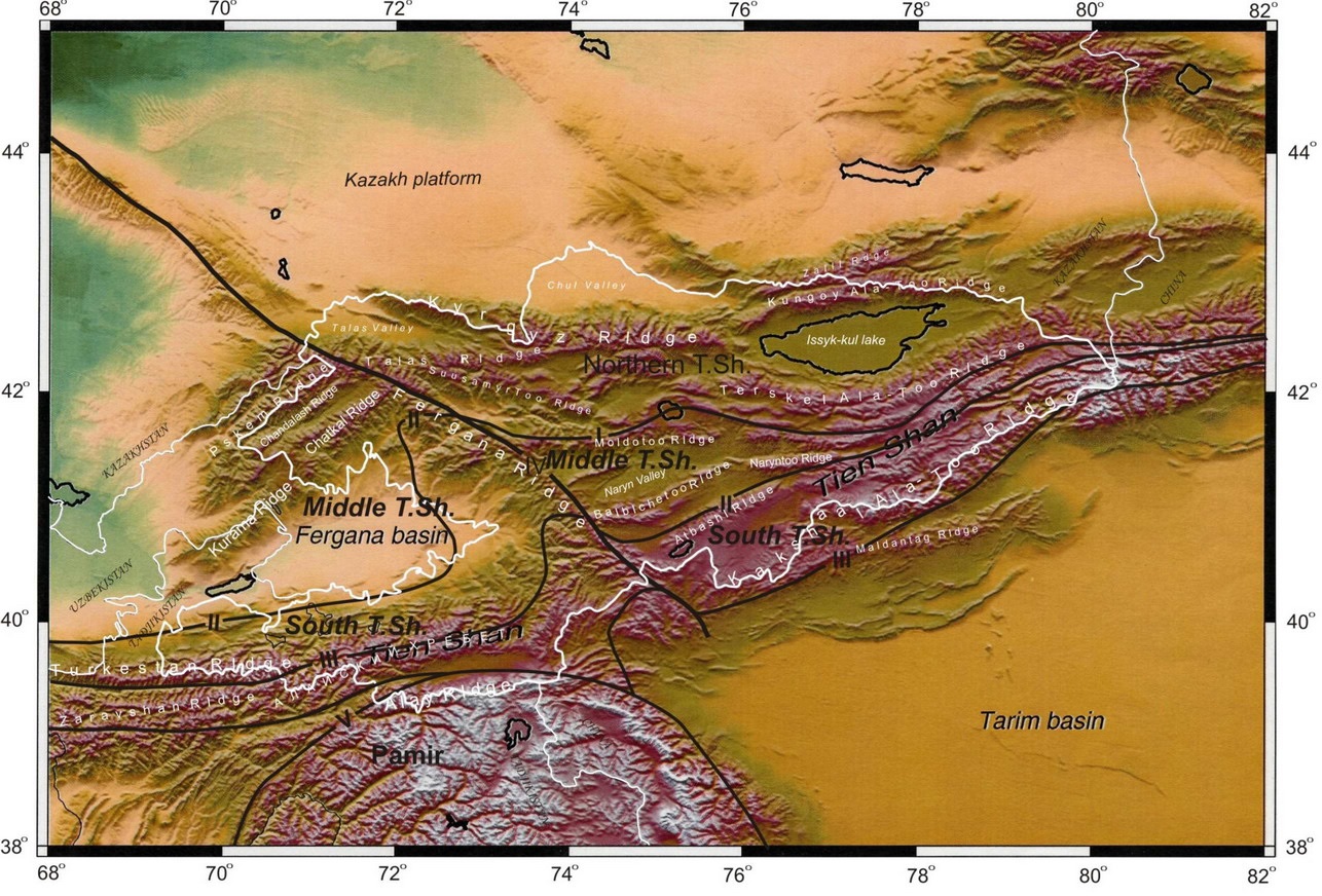
Route of the expedition
The route of the expedition is planned in such a way that it passes in the eastern and southern parts of Kyrgyzstan, with conveniently constructed logistics, along the main and high-mountain roads, some of the roads are used by tourists for travel. In this geo-expedition, the route is laid along the Bishkek-Torugart highway, and also to the east to the Issyk-Kul lake and almost completely crosses all the main structural-geological complexes of the Tien-Shan
During the route, the entire geological section will be shown, including the Lower Precambrian crystalline basement, the cover complexes and rifting of the Upper Proterozoic-Lower Paleozoic of the North Tien Shan paleo continental block, ocean bottom complexes and festoon islands associated with the Ishim-Naryn pale oceanic structures.
Further, in places of geological observations, riftogenic sections of the Upper Proterozoic and complexes of the passive continental margins of the Paleozoic of the Middle Tien Shan will be shown. In the Southern Tien Shan, the routes cover the Paleozoic ophiolite of the Turkestan paleo ocean and the carbonate platform of the Alai-Ulan paleo continental block. The places of manifestation of magmatism of Paleogene hot spots and the outputs of orogenic complexes associated with the newest mountain-forming processes will be demonstrated.
Also, during the expedition, modern morphostructural elements that participate in the structure of intermountain depressions and mountain ranges will be shown. During the route, the results of seismic events and characterizing them will be demonstrated morphostructures expressed in modern relief. Modern landscapes will be shown as a result of tectonic processes.
The excursion is designed for 14 days. During the expedition three field seminars are planned.
During field observations, a field lunch is provided, as well as tea or coffee.
Day 1. Arrival in Bishkek
Meeting at the airport of Bishkek. Hotel accommodation. Briefing and presentation of the expedition. Discussion of details, preparation for departure.
Day 2. Transfer to Chon-Kemin
Morning departure to the expedition. Excursion to the south of the Bishkek city. Study of neotectonic structures in the foothills of the Kyrgyz ridge, the place of observation 1. Further, the expedition’s route is directed to the east to the mining ore Ak-Tyuz village. Here, at two observation points, near Stop 2 (observation place), investigations of the crystalline basement of the Tien Shan. At Stop 2.1. Study of eklogitfazies of the Zailiiskiy Range. At Stop 2.2. Study of the magmatic (ophiolite) complex. Transition to Stop 3. Mountain, Kok-Too. Overlap of the Lower Ordovician (O1) to Precambrian granites. Overnight in a field tent camp in the floodplain of the Chon-Kemin river.
Day 3. Itinerary from Chon-Kemin to Kochkor village
Route to the creek Chalk. Stop 4. Studying the Cambrian festoon islands volcanic formation, the geological sequence of Cholok. Island-arc complex. Basalt. Then move to the mouth of the Chon-Kemin river, which joins the Chu river, to Stop 5. Study of the metamorphic complex. Migmatite complex of the crystalline basement of the Tien Shan. Moving to Stop 6. Boom gorge. Cretaceous-Paleogene (K-P) intraplate basalts. A study of a typical section of Cretaceous-Paleogene (K-P) basalts in the left side of the Boom gorge near the mouth of the Suluterek river.
Further the route of the expedition continues along the Boom gorge to the east to Stop 7. Here is the study of the Toguzbulak tectonic fault. The Bozbarmak anticline. Then drive to the picturesque stony of Ak-Olong desert.
Here, at Stop 8, a study of the sienites of the Permian period (P). The route continues towards the Kochkor village to Stop 9. Study of Katarchean gneisses of the Kochkor complex. Arrival to Kochkor. Accommodation in a guest house in Kochkor.
Day 4. Route Kochkor – valley of Tulek river
The route passes east of the high mountain lake Son-Kul. Along the way, excursions to geological objects will take place. Study of Stop 10. Precambrian rifting and shelfy rock complexes. Riphean of the Northern Tien Shan. The place of observation is in the valley of the Kara-Kodzhur river, 20 km from the route Kochkor – Naryn, Studies of geological formations. The geological formations of the Kara-Kujur river basin are of interest in many respects. Precambrian rifting and shelf complexes are represented by the most complete geological sections. Further excursion to the Tulek river basin. Study of Stop 11. Ophiolites of the Lower Paleozoic. Serpentinite melange. Overnight in a field tent camp in the valley of the Tyulek river.
Day 5. The river Tyulek – Naryn
In the morning, the way will continue to the Naryn city. Along the way, the route of the expedition leads to the valley of the Sarybulak river. Here at Stop 12, the study of the Devonian (D) granites. Further, walking tour to Stop 13. The valley of the Sarybulak river. Cambrian granites. Then the route continues to Stop 14. Dolon pass. Stratigraphic relationships of Cambrian-Ordovician deposits. The route continues towards Naryn, where on the way the excursion to Stop 15. Study of the “Line of Nikolaev”. Arrival to the Naryn city. Accommodation in hotel of Naryn.
Day 6. Geological excursions in the Naryn region
A trip to the confluence of Greater Naryn and Small Naryn. Stop 17. The mouth of the Small Naryn. Proterozoic porphyroids and thylloids. Further excursion in the Naryn area to Stop 16. Study of active faults of the Naryn section. In the evening, a seminar. Overnight in hotel in Naryn.
Day 7. The route Naryn – At-Bashi – Baetovo – Kazarman
In the morning, departure from Naryn towards the high-mountain At-Bashi village to the south-west along the same name valley. Along the way, neotectonic morphostructural formations form a modern relief. Stop 18. Study of the Accretion complex of the Southern Tian Shan. Then move to Stop 19. Study of the Ophiolite melange in the area of the Ak-Bayit village. On the way in the At-Bashi area, study of the bad lands.
Overnight in a tent camp near the pass.
Day 8. The route through the pass of Jaman-Too ridge – Baetovo – Kosh-Dobo – Kazarman
After the pass, the route runs through the badlands forming the terrace. Such terraces are developed in the foothills of the foothills of the Kochkor, Jumgal, Alabuga-Naryn, Atbashin and other basins at various heights. In some places, the accumulative cover is destroyed, causing the surface of the terrace to become erosive. Due to the intensive dismemberment of the Middle Quaternary surface by the channels of permanent and temporary flows, the relief has a typical wavy appearance. Stop 20. Flat plains and plumes of the Upper Quaternary age are widely developed and well preserved. All this testifies to the latest tectonic vertical movements. In the Inner Tian-Shan, this morphostructural complex is combined with unevenly distributed elevations of the foothills, the remnants forming a relief of the “badland” type. Deep river valleys in turn formed widely developed socle terraces. Typical areas of distribution of this relief are the valleys of the Alabuga, Kochkor and Middle Naryn basins. Accommodation in the hotel of the Kazarman village.
Day 9. Kazarman-Naryn
After breakfast, the route of the expedition continues to Naryn city. On the way, study of geological structures in the floodplain of the Naryn River . Studies of the contact of meso-Cainazoic and Paleozoic geological layers. Stop 21, stop at Kara-Koo pass for southern badlands panorama in Baetovo district. On the way, along the left bank of the Naryn River, in the Baetovo region on the vast northern foothills of the Jaman-Too mountain range, a trail of cone-shaped eruptions was formed, as well as morphostructures composed of meso-Cenozoic rock complexes. Formed landscapes, confined to the valley of the Alabuga River, are the result of neotectonic movements with well-defined wide socle terraces. Arrival to Naryn. Hotel accommodation. In the evening, a seminar.
Day 10. Naryn – Sarybulak – Arabel valley
In the morning the expedition’s route continues to the north-east to the stop Sarybulak and further along the valley of the Kara-Kujur river to the east towards the Arabel high plateau. Further, in the Arabel valley, a study of the modern, geological structure of the Adyrs. Tectonic evolution of the high-mountain semi-arid of Arabel valley. Glacial activity. Accommodation in a field tent camp.
Day 11. Arabel high plateau – Torsor pass – Barskaun – Karakol
In the morning the route of the expedition continues along the adyrs of the Arabel valley and leads to the Tosor pass, after which the expedition descends to the Issyk-Kul basin in the Barskoon village. On the shore of Issyk-Kul lake, overnight in a guest house.
Day 12. Borskoon – Karakol
On the way excursion to Jety-Oguz. Stop 21. Mesozoic rock complex. Excursion to hydrothermomineral springs.
Further to the Karakol city. Accommodation in the hotel of Karakol city. In the evening, a seminar.
Day 13. Karakol – Ananyevo – Semyonovka – Camping
On the way to Ananyevo village, studying the Ananyevsky landslide. Stop 22. From the valley of the river. Chon-Aksu, through the Kok-Bel pass, active faults of the epicentral zone of the Kemin earthquake of 1911 with M = 8.2 can be traced. The rupture is characterized by various types of fault formation mechanisms that combine thrust processes. Field workshop. Overnight in a field camp in the Semyonovsky gorge.
Day 14. Semyonov Gorge – Grigorievka – Cholpon-Ata – Bishkek
In the morning, we collected a field camp and moved to Stop 23 in the Grigorievsky gorge area.
Kungei granitoid batholith. One of the large granitoid batholiths of the Northern Tien Shan is the Kungei batholith, located in the eponymous ridge and traced for 230 km, with a maximum width of 15 km. Late Ordovician-Early Silurian (O2-S1) granitoids are represented here by rocks of three phases of implantation. Return to Bishkek. Hotel accommodation. Summarizing.